News
Met Office issue 24-hour heavy snow warning for Greater Manchester
Check before you travel as forecasts predict ‘disruptive’ snowfall

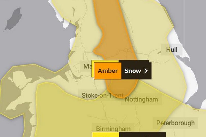
The Met Office has issued an amber weather warning for parts of the UK today as Greater Manchester is expected to see heavy snowfall — the warnings are in place until tomorrow afternoon.
On Wednesday March 8th the Met Office issued an amber weather warning covering parts of the North West with heavy snow expected to cause ‘significant disruption’ for the region. Snow is expected to fall from Thursday March 9th after parts of the North West experienced snowfall from Wednesday afternoon.
The warning says heavy snow is due from 3pm today and it covers a large area of Northern England and parts of Greater Manchester, including the Pennines — covering parts of Oldham, Tameside and Rochdale. The alert, which lasts until noon on Friday, states: “Heavy snow is likely to cause significant disruption on Thursday afternoon and Friday morning.”
Today, the Met Office weather forecast reads that conditions will begin to turn: ‘unsettled as another band of snow, sleet and rain moves northwards’. More ‘disruptive’ snowfall is also expected to continue ‘into the evening and overnight, particularly across the higher ground in the east’.


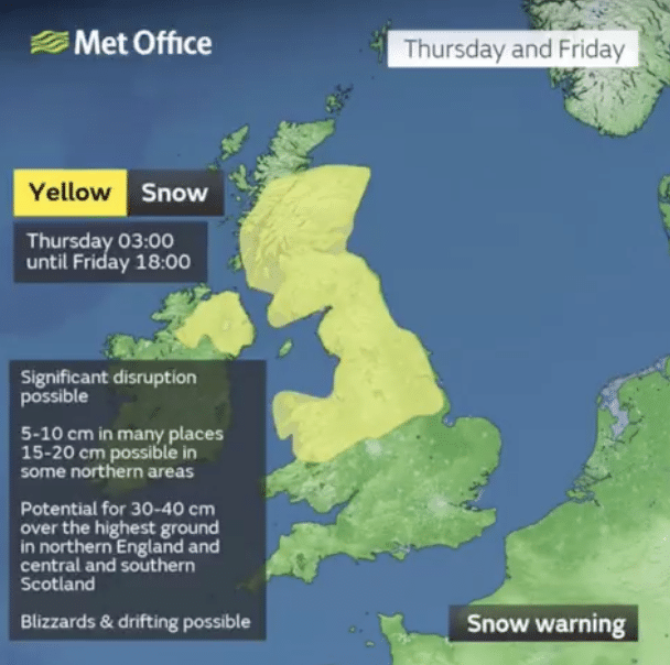
The streak of wintry weather has been attributed to an arctic blast, which is expected to bring more snow and ice throughout the UK, the Met Office said. A number of national severe warnings for snow and ice were issued earlier this week with forecasters saying further warnings, or updates to the current warnings, are ‘very likely’.
Dozens of flights were disrupted in the south of England amid snowfall across the nation following the coldest night of the year on Tuesday March 7th.
As reported in The Manchester Evening News, Met Office spokesperson Nicola Maxey said the minus 15.4C temperature recorded on Tuesday night meant it was the coldest in March since 2010. Ms Maxey said an ‘Arctic maritime air’ drifting over the UK from the North is causing the widespread snowfall and it could generate ‘blizzard conditions’ today.

The Met Office has said temperatures at Kinbrace in the Highlands dropped to this year’s low of minus 15.4C overnight – the lowest March temperature recorded in over a decade.
Bristol Airport temporarily closed for ‘snow clearing operations’ with morning flights cancelled, the delays are also affecting passengers at other airports in the south of England.
National Highways has urged drivers in the West Midlands and the East of England not to travel unless their journey is essential. Forecasters have predicted night-time sub-zero temperatures in all four UK nations until at least Friday, with snow sweeping the nation in the coming days.